

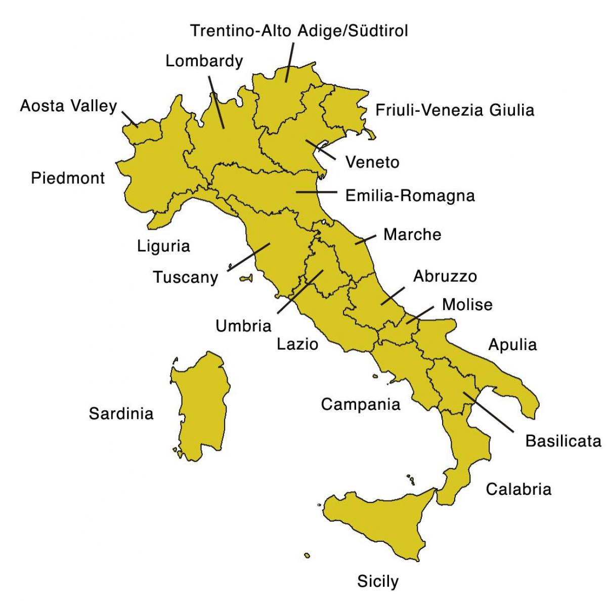
You can find on this page the Italy region map to print and to download in PDF. The Italy political map presents states, regions, provinces and surrounding areas of Italy in Europe.

The Italy regions map shows surrounding areas and provinces of Italy. This administrative map of Italy will allow you to know regions of Italy in Europe. The Italy regions map is downloadable in PDF, printable and free.
Italy is divided into 20 different regions as its mentioned in Italy regions map, including the islands of Sicily and Sardinia in the Mediterranean Sea which are each a separate region. Each region has its own unique culture, customs, and cuisine so you will find a lot of differences between regions in the north and those in the south. The central Italy region of Tuscany is probably the most well-known and most visited by tourists.
The regions of Italy are the first-level administrative divisions of the state, constituting its first NUTS administrative level as you can see in Italy regions map. There are twenty regions, of which five are constitutionally given a broader amount of autonomy granted by special statutes. Each region is divided into provinces (except for Aosta Valley, which has no province). Regions are autonomous entities with powers defined in the Constitution.
Every region in Italy has a statute that serves as a regional constitution (see Italy regions map), determining the form of government and the fundamental principles of the organization and the functioning of the region, as prescribed by the Constitution of Italy (Article 123). These regions, whose statutes are approved by their regional councils, were created in 1970, even though the Italian Constitution dates back to 1948. Since the constitutional reform of 2001 they have had residual legislative powers.
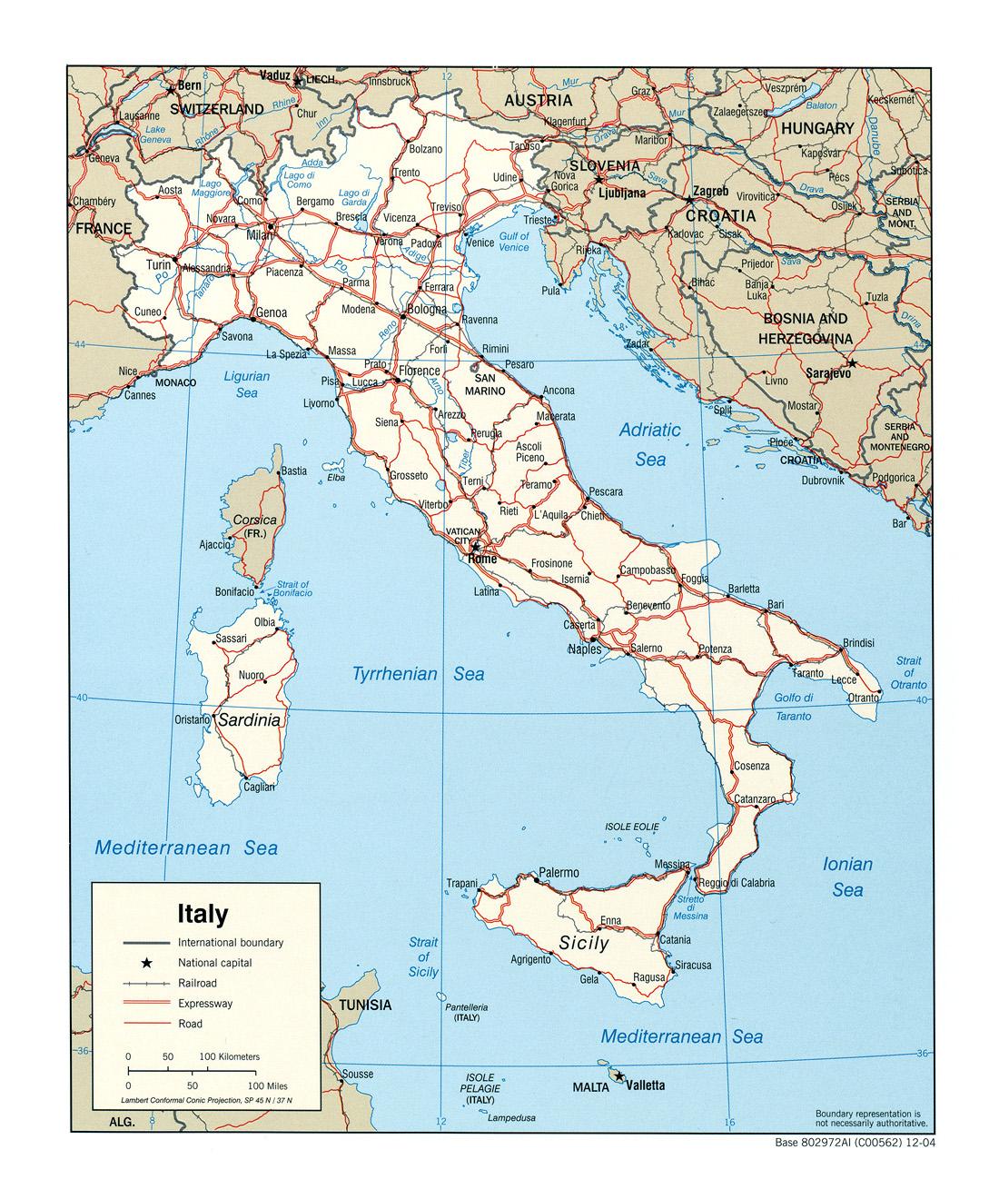
The Italy political map shows regions and provinces of Italy. This administrative map of Italy will allow you to show regions, administrative borders and cities of Italy in Europe. The Italy political map is downloadable in PDF, printable and free.
Italy has been a unitary parliamentary republic since 2 June 1946, when the monarchy was abolished by a constitutional referendum. The President of the Italian Republic (Presidente della Repubblica), currently Giorgio Napolitano since 2006, is Italy head of state. The President is elected for a single seven years mandate by the Parliament in joint session as its shown in Italy political map. Italy has a written democratic constitution, resulting from the work of a Constituent Assembly formed by the representatives of all the anti-fascist forces that contributed to the defeat of Nazi and Fascist forces during the Civil War.
The politics of Italy is conducted through a parliamentary, democratic republic with a multi-party system as its mentioned in Italy political map. Executive power is exercised collectively by the Council of Ministers, which is led by the President of the Council of Ministers, referred to as "Presidente del Consiglio" in Italian. Legislative power is vested in the two houses of parliament primarily, and secondarily on the Council of Ministers. The judiciary is independent of the executive and the legislative branches.
Italy dramatic self-renewal transformed the political landscape between 1992 and 1997. Scandal investigations touched thousands of politicians, administrators, and businessmen; the shift from a proportional to an Additional Member System (with the requirement to obtain a minimum of 4% of the national vote to obtain representation as you can see in Italy political map) also altered the political landscape.

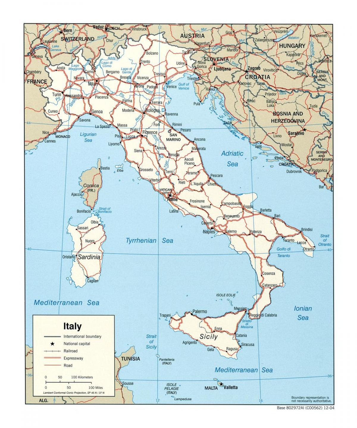
The Italy states map shows all departments and regions of Italy. States map of Italy will allow you to know areas and cities of Italy in Italy. The Italy states map is downloadable in PDF, printable and free.
In Italy, a state (provincia) is an administrative division of intermediate level between a municipality (comune) and a region (regione). A state is composed of many municipalities (comune), and usually several states form a region. The region of Aosta Valley is the only exception being the state coincident with the region. The three main functions devolved to states are: Local planning and zoning, Provision of local police and fire services. Transportation regulation (car registration, maintenance of local roads, etc.). There are 110 states in Italy as its shown in Italy states map. Lombardy has the most states, with 12. The number of provinces in Italy has been steadily growing in recent years, as many new ones are carved out of older ones.
Each state in Italy is headed by a President assisted by a legislative body, the Provincial Council, and an executive body, the Provincial Executive (see Italy states map). President and members of Council are elected together by resident citizens: the coalition of the elected President (who needs an absolute majority in the first or second round of voting) gains the three fifths of the Council seats. The Executive is chaired by the President who appoint others members, called assessori.
In each state in Italy there is a Prefect (prefetto) as its mentioned in Italy states map, a representative of central government who heads an agency called prefettura-ufficio territoriale del governo. The Questor (questore) is the head of State Police (Polizia di Stato) in the state and his office is called questura. There is also a state police force depending from local government, called provincial police (polizia provinciale).